Mount Tarawera Guided Walks: Three Ways to the Crater
Can you walk up Mount Tarawera on your own?
No. Mount Tarawera is privately owned by local iwi and closed to independent access. The only ways onto the mountain are booked guided experiences: a 4WD ride to the crater rim, a walk that continues into the crater with a scree descent back down, or a helicopter flight that lands on the summit.
One mountain, one owner, three ways up
Mount Tarawera looks close enough from Rotorua to walk to. It is not somewhere you can drive up on your own initiative, park at a trailhead, and start climbing. The mountain and the land around it are privately owned by Ngāti Rangitihi and other Te Arawa hapū, and there is no public right of way onto it. Every visit to the summit or the crater happens through a booked arrangement with the landowners, run in practice through licensed tour operators.
That single fact shapes everything else about visiting Mount Tarawera: there is no free version of this trip, no back way in, and no way to substitute your own hiking boots and a map for a booking. What you do get to choose is which of three access routes suits your time, budget, fitness and appetite for exposure: a 4WD ride to the crater rim, a guided walk that continues into the crater and comes back down through loose scree, or a helicopter flight that lands on the summit itself.
Why access is restricted at all
Mount Tarawera is not a scenic backdrop dressed up as off-limits for marketing effect. Public access to the mountain was progressively withdrawn after a period when visitors climbed it independently, sometimes off marked routes, causing erosion on unstable crater walls and generating safety incidents that fell on the landowners and emergency services to resolve. The mountain is also an ancestral site of deep significance to the hapū who hold it, and access decisions sit with them, not with a regional tourism body or the Department of Conservation.
The result is a controlled model: a small number of operators hold agreements to bring visitors onto the mountain, in numbers and along routes the landowners accept, with revenue returning to the iwi. It is a similar structure to Whakarewarewa’s living village, where Tūhourangi Ngāti Wāhiao control who enters their community, except here the concern is a physically unstable volcanic landscape rather than a residential one. If you have already read about Te Arawa history in Rotorua, this pattern of iwi-controlled access to significant sites will be familiar.
Practically, this means: no permit you can apply for on your own, no unguided track, and no way to reach the crater by turning up at a car park. It also means numbers on the mountain at any one time are limited, which changes how a visit feels compared with a crowded, first-come public site.
The 1886 eruption made the mountain worth visiting like this
Before 10 June 1886, Tarawera was a forested ridge with three peaks, not obviously volcanic to the eye. That night it tore open along a roughly 17-kilometre rift, throwing out ash and rock in one of the country’s most violent recorded eruptions. More than a hundred people died, several villages were buried or destroyed, including Te Wairoa, and the Pink and White Terraces, then the country’s best-known natural attraction, were lost. You can read the fuller account in the 1886 eruption story and in what happened to the Pink and White Terraces.
What the eruption left behind is what a guided visit today actually shows you: a chain of craters strung along the summit ridge, walls of red and black scoria, and a scale of destruction still legible in the landform itself rather than smoothed over by more than a century of weather. This is not a dormant cone with a neat symmetrical crater. It is a mountain that visibly came apart, and the routes described below are built around getting close to that rift without pretending it is a casual walk in a park.
Route one: 4WD to the crater rim
The most accessible of the three options uses a private access road, closed to the public, that specialist vehicles are permitted to drive. This gets visitors to the crater rim without a long walk, and from there a shorter walk along the top of the rim gives views down into the craters and out over the Bay of Plenty, Lake Tarawera and, on a clear day, across much of the eastern volcanic zone.
This route suits people short on time, travelling with a broader range of fitness levels in a group, or who want the views and the geology without a demanding physical component. It does not typically include descending into the crater itself. If a road up an active-looking volcanic mountain sounds unusual, it’s a similar principle to the geothermal 4WD terrain covered in the wider Rotorua 4WD and off-road tours guide, adapted here to a single-operator access agreement rather than open trail networks.
Route two: the guided walk into the crater, down through scree
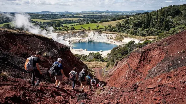
The more involved option combines the vehicle access with an extended walk that goes beyond the rim and down into the crater complex itself, before descending the outer slope through loose volcanic scree, a surface of fine, ash-like rock that shifts underfoot with each step. Guides brief the technique for this before you start: short controlled steps, weight back, letting the scree take the impact rather than fighting it.
Mount Tarawera Volcanic Crater Guided Walk Experience is built around exactly this format, and it is the option that gets closest to the geology: standing inside a crater rather than looking down into it, with the guide explaining the sequence of vents that opened in 1886 along the way.
This is a real physical undertaking rather than a stroll. Expect a walk of several hours in total including the scree section, on ground that offers no shade and can be windy and exposed at the rim. Sun protection, layers and sturdy footwear matter here in a way they do not for the 4WD-only visit; New Zealand’s summer UV is genuinely severe at this exposed altitude, and there is no cover on the crater rim. Anyone uneasy on loose, steep ground, or travelling with young children, is generally better suited to route one.
For visitors already planning a Kaituna rafting trip, some operators package the two together, saving a day’s logistics and combining a whitewater morning with a volcanic afternoon:
Rotorua: Kaituna Rafting Mount Tarawera Guided Hike ComboIf rafting on its own is more what you’re after, the separate Kaituna River rafting guide and which Rotorua river to raft cover that choice in more depth, including how Tutea Falls compares to the Kaituna’s other rapids.
Route three: helicopter, with a landing on the summit
The third route removes the walking altogether, or reduces it to a short stretch on the summit itself. Scenic flight operators running helicopter routes over the volcanic zone include Tarawera landings as part of some itineraries, putting visitors on the crater rim without the drive or the walk, then lifting off again after a set amount of time on the ground.
This is the fastest way to see the crater and the only one that removes physical exertion almost entirely, which makes it the practical choice for visitors with mobility limitations, very tight schedules, or simply a preference for seeing the volcanic landscape from the air as well as on the ground. It is also the most weather-dependent of the three: helicopter operations in this region cancel or reschedule readily around wind, cloud base and visibility, more so than the 4WD road.
Helicopter access to Tarawera specifically runs through the same small set of operators holding landing rights with the iwi, so availability can be limited compared with general scenic flights over the region. For a wider look at flightseeing choices around Rotorua and Taupō, including routes that pass over Tarawera without landing, see Rotorua scenic flights compared. Two other helicopter experiences worth knowing about, though over different mountains entirely, are a flight from Tauranga over the still-active Ruapehu:
Mount Ruapehu Scenic Flight from Taurangaand, further south near Taupō, a helicopter route over Ngāuruhoe, the cone familiar from film as Mount Doom:
Taupō: Mount Doom Scenic Helicopter FlightNeither of those two flies over or lands on Tarawera itself; they are useful comparisons if you’re weighing up whether a helicopter experience anywhere in this volcanic corridor is worth the cost, and both sit within the same broader Taupō volcanic zone that runs from Whakaari in the north down to Ruapehu in the south.
Comparing the three routes
| Route | Physical demand | Time on the mountain | Best suited to |
|---|---|---|---|
| 4WD to crater rim | Low — short walk along the rim | Shorter visit | Groups with mixed fitness, limited time, no interest in descending |
| Guided walk with scree descent | High — steep, loose ground, several hours | Longest visit, most time inside the crater | Fit, confident walkers wanting the closest look at the geology |
| Helicopter with landing | Very low — brief time on foot at the summit | Shortest, but weather-dependent | Mobility limits, tight schedules, a preference for aerial views |
None of these prices are fixed here since operators, seasons and combination packages change what is included; check current details directly through the operator before booking.
What to bring, whichever route you choose
Because every route reaches an exposed summit with no shelter and unpredictable weather, some preparation applies across all three options:
- Footwear. Closed, sturdy shoes with grip are expected for the 4WD and helicopter routes; the guided walk with scree descent needs proper walking or hiking shoes, not sandals or fashion sneakers.
- Sun protection. There is no shade at the crater rim. New Zealand’s UV index climbs to extreme in summer, and this is a genuine risk here, not a formality: hat, sunscreen and sunglasses matter even on a cool-looking day.
- Layers. Wind at altitude on an exposed volcanic ridge is noticeably cooler and stronger than in Rotorua township, whatever the forecast says for the town.
- Water. Especially for the extended walk, which runs for hours with no facilities en route.
- Camera or phone with charge. The view across Lake Tarawera, the Blue and Green Lakes and the Bay of Plenty coast from the rim is one of the more distinctive outlooks in the region, and battery drains faster in wind and cold.
Weather and ground conditions on Mount Tarawera can change how any of these tours run, and operators can reschedule a 4WD or helicopter departure or shorten a walking route at short notice for safety reasons. Confirm current conditions and any changes directly with the operator close to your booking date rather than assuming the itinerary described here will run unmodified. For the geothermal side of visiting this region generally, the Rotorua geothermal safety guide covers ground stability, hydrogen sulphide and other conditions specific to this landscape.
Fitting Mount Tarawera into a Rotorua itinerary
A 4WD or helicopter visit to Tarawera fits into a single morning or afternoon and can sit alongside a geothermal park visit or a cultural experience on the same day. The extended guided walk with the scree descent is closer to a half-day-plus commitment once transfers are included, and is better planned as its own dedicated activity rather than squeezed between two other bookings.
If you are still working out how much time to give Rotorua overall, how many days in Rotorua sets out a broader framework; Tarawera is one of the activities worth allocating a specific half-day or full day to rather than treating as a quick add-on, precisely because getting there and back, and the booking itself, take real time regardless of which of the three routes you choose.
Mount Tarawera guided walks: questions before you book
Can you walk up Mount Tarawera on your own?
No. The mountain is privately owned by local iwi and there is no public track or freedom-camping-style access. Every ascent, whether by vehicle, on foot from the rim, or by air, is booked through a licensed operator.
Why is Mount Tarawera closed to independent hikers?
The mountain and the land around it belong to Ngāti Rangitihi and other Te Arawa hapū. Public access was withdrawn some years ago after unmanaged visits caused erosion and safety incidents on the crater rim, and because the mountain holds deep cultural significance as an ancestral site.
What is the difference between the 4WD tour and the guided walk?
A 4WD-only visit takes you up an access road to the crater rim for the views and a shorter walk along the top. A guided walk experience adds a walking section beyond the rim into the crater itself, usually finishing with a descent through loose volcanic scree rather than retracing the same path.
Is the scree descent difficult?
It is steep and requires reasonable fitness and confidence on loose, ash-like ground, but it does not require technical climbing skill. Guides set the pace, provide instruction on foot placement, and turn the descent back if conditions or a guest’s condition make it unsafe.
Can you land on Mount Tarawera by helicopter?
Yes, some scenic flight operators include a landing on the summit as part of a helicopter experience over the volcanic zone. This is the fastest and least physically demanding of the three access routes, and the only one that does not involve walking to reach the crater.
How long did the 1886 eruption take to happen, and can you still see its effects?
The eruption on 10 June 1886 lasted a matter of hours but reshaped the mountain, opening a chain of craters along its length and burying villages including Te Wairoa. The rift and crater walls seen today on a guided visit are the direct result of that night.
Do you need to book Mount Tarawera access in advance?
Yes. Because every route onto the mountain runs through a single operator arrangement with the landowners, places are limited and tours can sell out, particularly in the warmer months. Weather also affects the 4WD road and helicopter flights, so operators may reschedule at short notice.
Is Mount Tarawera suitable for children or people with limited mobility?
The 4WD ride to the rim suits most people who can manage a short walk on uneven ground. The extended walk with the scree descent is more physically demanding and generally not suited to young children or anyone with knee or balance concerns. A helicopter landing is the most accessible option but is also the most weather-dependent and expensive.
Volcano & crater tours on GetYourGuide
Verified deep-linked GetYourGuide tours. Book through these links and we earn a small commission at no cost to you.
Photos show the destination, not the operator's own images.