Explore Rotorua and its surroundings by area
Five areas across the central North Island — from Rotorua's steaming caldera and the Whakarewarewa valley to Lake Taupō, the Bay of Plenty coast, the Waikato and the Coromandel, all within a day's drive.
Must-visit areas
The geothermal core — Whakarewarewa, Te Puia and Pōhutu geyser, Wai-O-Tapu's Champagne Pool and the Redwoods — plus Hobbiton at Matamata, the Waitomo glowworm caves and Lake Taupō.

Hobbiton Movie Set
Hobbiton's 44 hobbit holes sit on a working Waikato sheep farm, visited only by guided tour.

Huka Falls, Taupō
220,000 litres a second forced through a 15-metre gorge: how to see Huka Falls on foot, by jet boat, or from the air, near Taupō.

Lake Taupō
A 616 km² supervolcano crater: boat or kayak to the Mine Bay Māori rock carvings, hot-water beaches, and trout fishing on Lake Taupō.

Matamata
Matamata is a Waikato dairy town that became a film location. What Hobbiton actually involves, and what else the area offers around it.

Mount Maunganui
Mauao, the 232m cone at the tip of a sand spit, with a surf beach on one side, Tauranga's port on the other, and hot pools at its base.

Mount Tarawera: The Mountain That Split in 1886
Mount Tarawera split open on 10 June 1886, burying the Pink and White Terraces. Access today is guided only: 4WD, helicopter or crater walk.

The Redwoods, Whakarewarewa Forest
Rotorua's 1901 redwood forest: one of the world's top mountain bike networks, a treetop walkway by day and night, and free walking tracks.

Rotorua
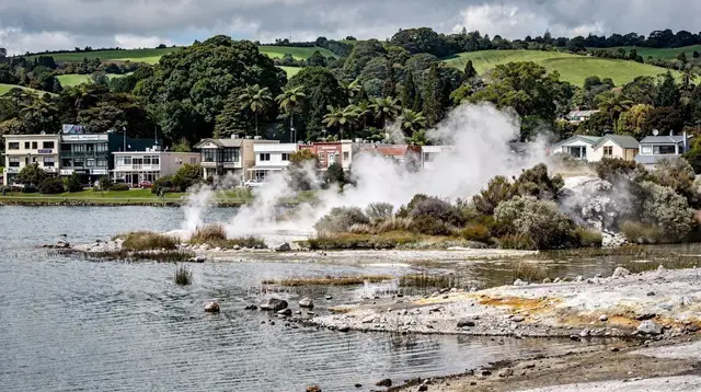
Rotorua sits on an active caldera beside its lake: what's walkable from the centre, why it smells of sulphur, and what needs a car.

Taupō
Taupō sits inside a supervolcano crater beside New Zealand's largest lake, about an hour from Rotorua, with clear water and mountain views.

Tauranga
Tauranga is the North Island's busiest cruise port and sunniest city, about an hour from Rotorua and a base for day trips inland.

Te Puia
Te Puia in Rotorua: when Pōhutu geyser erupts, what to expect at the Māori Arts and Crafts Institute, and the difference between Te Rā and Te Pō.

Tongariro National Park
New Zealand's first national park and a dual World Heritage site: three volcanoes, the Alpine Crossing, and Ngāti Tūwharetoa's mountains.

Wai-O-Tapu
Champagne Pool, Devil's Bath, and the 10:15 am Lady Knox Geyser show - what Wai-O-Tapu actually looks like, and whether it earns the trip.

Waimangu Volcanic Valley
Waimangu is the only geothermal valley in the world with a known birth date. A downhill walk that ends with a cruise on Lake Rotomahana.

Waitomo Caves
Waitomo's glowworm caves: a scenic boat ride, black water tubing or a treetop zipline – how the three compare and which one fits your day.

Whakarewarewa Village
Inside Whakarewarewa, the living Māori village where Tūhourangi Ngāti Wāhiao still cook by geothermal steam and guide visitors through their home.
More to explore
Mount Tarawera and the valleys the 1886 eruption created, the Bay of Plenty coast at Mount Maunganui and Whakatāne, Tongariro National Park, and the Waikato towns on the way west.

Cathedral Cove
Cathedral Cove's limestone arch, on the Coromandel: how to reach it by foot, kayak or boat, and what the walking track's storm damage means today.

Coromandel Peninsula
Kauri forests, Cathedral Cove and a crest road about three hours from Rotorua — what a Coromandel day trip actually costs in driving time.

Hamilton
Hamilton on the Waikato River: award-winning themed gardens and a practical stopover between Rotorua, Waitomo and Raglan.

Hell's Gate (Tikitere): Rotorua's Most Active Geothermal Park
Hell's Gate near Rotorua is the region's most active geothermal park, with mud pools, sulphur vents, and New Zealand's only walk-in mud bath spa.

Lake Rotoiti: Hot Springs Reached Only by Water
Lake Rotoiti's Manupirua hot springs are reachable only by boat or kayak. Evening paddles, glowworms, and the water-only access explained.

Lake Rotorua
Lake Rotorua is a flooded volcanic crater ringed by the town. What to see on the lakefront, Mokoia Island, and where swimming actually works.

Lake Tarawera
Lake Tarawera beneath its volcano, the geothermal Hot Water Beach at Te Rata Bay, and the Tarawera Trail on foot, boat or kayak.

Okere Falls and the Kaituna's Tutea Falls
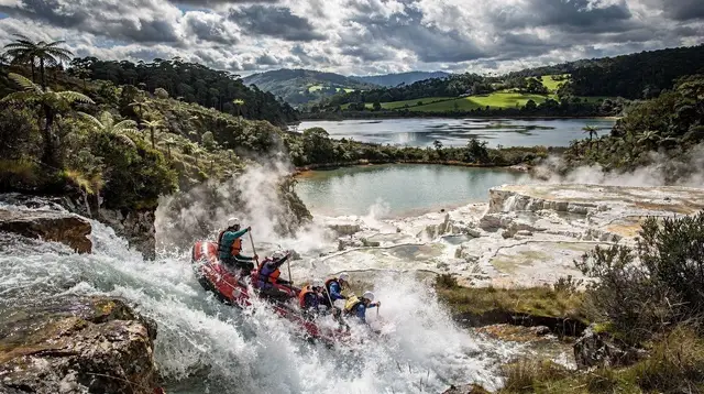
What rafting 7-metre Tutea Falls on the Kaituna is really like, and the free walkway to see it without getting in a raft.

Orakei Korako, The Hidden Valley
Orakei Korako is a boat-access geothermal valley between Rotorua and Taupō, with New Zealand's largest active silica terraces and Ruatapu Cave.

Raglan
Raglan is a small surf town on the Waikato west coast, home to Manu Bay's long left-hand break and canyoning routes on Mount Karioi.

Te Wairoa: The Buried Village of the 1886 Eruption
The village Mount Tarawera buried in 1886, excavated and preserved as an archaeological site — the story no geothermal park in Rotorua tells.

Whakaari / White Island
Whakaari / White Island is an active volcano 48 km off the Bay of Plenty coast. Landings ended after the 2019 eruption; flights and boat trips remain.

Whakatāne
Whakatāne: New Zealand's sunniest town, a harbour for dolphin cruises, and the historic departure point for Whakaari / White Island.
Off the beaten path

Blue Lake and Green Lake (Tikitapu and Rotokākahi)
Tikitapu (Blue Lake) and Rotokākahi (Green Lake) sit side by side near Rotorua. One is open to everyone, the other is tapu. Here is why.

Blue Spring, Te Waihou
Te Waihou's Blue Spring: 11°C water of near-total clarity, reached by a short walk from Leslie Road or the full Te Waihou Walkway from Whites Road.

Cambridge
Cambridge is Waikato's horse country: thoroughbred studs, the national rowing lake at Karāpiro, and evening kayak trips to riverside glowworms.

Craters of the Moon, Taupō: The Thermal Field a Power Station Made
Craters of the Moon near Taupō formed after the Wairākei power station lowered underground pressure. It is the cheapest thermal walk in the region.

Hamurana Springs
The North Island's deepest spring, an easy hour's walk under redwoods on Lake Rotorua's north shore, water near 10°C year-round.

Hot Water Beach
Hot Water Beach on the Coromandel Peninsula: dig your own hot pool at low tide, why timing matters, and why swimming beyond it is risky.

Ōhinemutu
Ōhinemutu, Rotorua's lakeside Māori village: St Faith's church, its etched Christ, steaming ground, and how to visit a lived-in place with respect.

Ōhope Beach
Ōhope Beach's eleven kilometres of sand and the oyster farms of Ōhiwa Harbour, next to Whakatāne, about 1h30 from Rotorua by road.

Tūrangi
Tūrangi sits at the south end of Lake Taupō, the country's trout fishing base and the closest town to the Tongariro Alpine Crossing.
Good to know about Rotorua and its surroundings by area
Rotorua is a city of around 60,000 people built on an active caldera in the middle of the Taupō Volcanic Zone, a roughly 250-kilometre tear in the earth's crust running through New Zealand's North Island. Steam rises from storm drains, public parks and private gardens across town, and the smell of hydrogen sulphide is part of daily life. The city sits at the heart of Te Arawa country, and Māori culture here is lived rather than staged for visitors; Rotorua has drawn tourists since the 1880s, making it one of the country's oldest destinations.
In the city itself, Whakarewarewa is a living Māori village, home to Tūhourangi Ngāti Wāhiao, where food is still cooked in geothermal steam, and it shares a thermal valley with Te Puia, the national institute of Māori arts and crafts and home to the Pōhutu geyser, which erupts once or twice an hour to heights of around 30 metres. About 27 kilometres south along State Highway 5, Wai-O-Tapu holds the Champagne Pool, the Devil's Bath and the Lady Knox geyser, triggered daily at 10:15am.
Waimangu Volcanic Valley formed in the eruption of 10 June 1886 and is the only geothermal system on earth with a known birth date, while Hell's Gate, at Tikitere, is the most active site in the area and the only one with a mud bath; Orakei Korako is reached by boat. Mount Tarawera, at 1,111 metres, erupted that same night in 1886, killing more than a hundred people and destroying the Pink and White Terraces, and can now only be visited on a guided tour, while Te Wairoa, the buried village, was one of the settlements lost that night. Ōhinemutu, a lakeside village belonging to Ngāti Whakaue, holds St Faith's Church, and Kuirau Park is a free geothermal park in the city centre.
The Government Gardens surround the 1908 Bath House, and The Redwoods, or Whakarewarewa Forest, is a stand of Californian redwoods planted in 1901 with around 180 kilometres of mountain-biking trails and a canopy walkway open by day and by night. On the Kaituna River, Okere Falls includes Tutea Falls, a 7-metre drop said to be the highest commercially rafted waterfall in the world. Rotorua's lakes — Rotorua, Rotoiti, Tarawera, Ōkataina, Tikitapu and Rotokākahi, the last one tapu and off-limits — ring the city, and Hamurana Springs sits on the northern shore of Lake Rotorua.
4-kilometre walk that takes six to eight hours, and the volcanic cones of Ngauruhoe and Ruapehu, the latter reaching 2,797 metres. Also an hour away, the Bay of Plenty is centred on Tauranga, the country's busiest port and a regular cruise-ship stop, alongside Mount Maunganui and its Mauao headland (232 metres), the town of Whakatāne, the roughly 11-kilometre Ōhope Beach, and Whakaari, or White Island, an active volcano 48 kilometres offshore.
West of Rotorua, the Waikato region holds Matamata and the Hobbiton Movie Set, 50 minutes away, with its 44 hobbit holes built as permanent structures in 2011 and the Green Dragon Inn; Waitomo, two hours away, with its limestone caves and Arachnocampa luminosa glow-worms, explored by boat, black-water rafting or through the Ruakuri and Aranui caves; the city of Hamilton; Cambridge and Lake Karāpiro; the Blue Spring at Te Waihou; and Raglan, known for one of the longest left-hand surf breaks in the world at Manu Bay.
Three hours away, the Coromandel Peninsula holds Cathedral Cove and Hot Water Beach, where visitors dig their own thermal pool in the sand for about two hours either side of low tide.
Frequently asked questions about Rotorua and its surroundings by area
What are the main regions around Rotorua?
Rotorua itself, on its geothermal lake; Taupō, an hour south around New Zealand's largest lake and Tongariro National Park; Bay of Plenty, an hour north-east around Tauranga; Waikato, home to Hobbiton and the Waitomo Caves; and the Coromandel Peninsula, three hours east.
How do you get to Rotorua?
Most visitors drive in from Auckland, about three hours north, or fly into Rotorua Airport, which has domestic connections. The city works well as a base, since most of the region's attractions sit within a couple of hours by road.
Are Hobbiton and Waitomo actually in Rotorua?
No. Hobbiton is near Matamata, about 50 minutes away, and the Waitomo Caves are about two hours away, both in the Waikato region — worth visiting from Rotorua as a base, but not part of the city itself.
What is the Taupō Volcanic Zone?
A roughly 250-kilometre stretch of active geothermal and volcanic activity through the central North Island, including Rotorua's geothermal fields, Lake Taupō's caldera and the volcanoes of Tongariro National Park.
Can I visit Whakaari / White Island from Rotorua?
Not by landing on it — boat and helicopter landings stopped after the fatal eruption of December 2019. Boat trips that approach the island and scenic flights over it still operate from the Bay of Plenty.
Sightseeing day tours on GetYourGuide
Verified deep-linked GetYourGuide tours. Book through these links and we earn a small commission at no cost to you.
Photos show the destination, not the operator's own images.