Rotorua Scenic Flights Compared: Floatplane, Helicopter or Whakaari
What is the difference between a floatplane and a helicopter scenic flight from Rotorua?
A floatplane takes off and lands on the lake and stays in the air the whole flight, covering the geothermal valleys and Mount Tarawera from altitude. A helicopter can do the same route but can also land on Tarawera's crater rim or push further to Tongariro or the Bay of Plenty coast, which costs more but adds time on the ground.
Three aircraft, three different views of the same volcanic zone
Rotorua sits inside the Taupō volcanic zone, and almost everything that makes the region worth looking at from the air is volcanic: a caldera lake, a mountain that split open in 1886, a steaming coastal cone, and further south a chain of active peaks. Three kinds of aircraft cover this ground from Rotorua and the wider Bay of Plenty — floatplane, helicopter, and fixed-wing — and each one answers a slightly different question. A floatplane answers “what does the lake and the geothermal valley look like from above.” A helicopter that lands on Mount Tarawera answers “what does it feel like to stand inside a 1886 crater.” A longer flight toward Whakaari / White Island or south to Tongariro National Park answers “how big is this volcanic zone, really.”
None of them is the objectively better choice — they show different things for different amounts of time and money, and this guide sets out what each one actually delivers.
Floatplane from the Rotorua lakefront
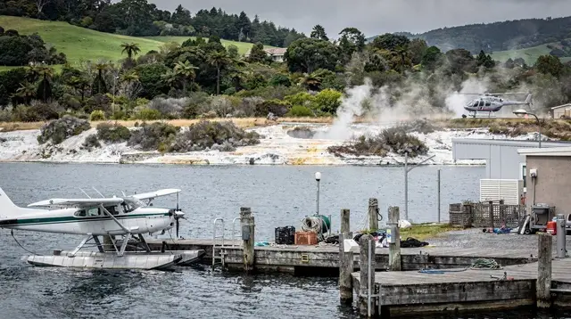
The floatplane is the option based closest to the town centre: it takes off and lands directly on Lake Rotorua, which means no drive to an airfield and no time lost getting into position. The typical route climbs over the geothermal features around the lake edge, crosses toward Lake Tarawera, and gives a full view of Mount Tarawera’s split summit and the string of craters that opened along it in the 1886 eruption, before returning along the lakeshore. It stays in the air for the whole flight — no landing — which keeps the price at the lower end of the scenic-flight scale and the flight itself short, usually somewhere between fifteen and thirty minutes depending on the route chosen.
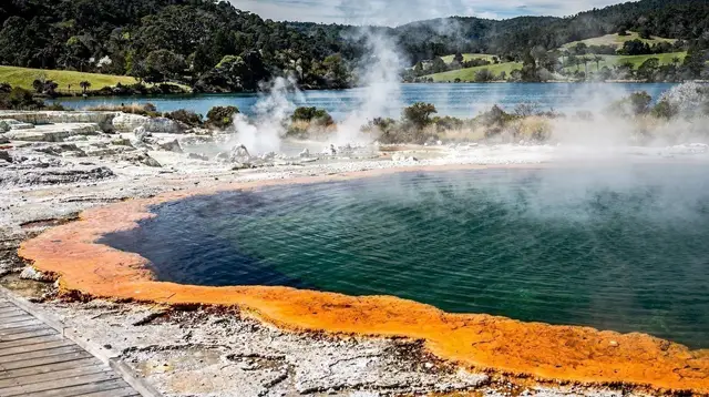
What a floatplane is good at is context: from a few hundred metres up, the caldera shape of Rotorua’s own lake becomes obvious, and the geothermal valleys read as a pattern rather than as a series of separate stops. It’s a good first orientation to the region before or after visiting the ground-level sites, and it works well as a short add-on to a day that already includes Whakarewarewa or Te Puia rather than as the centrepiece of a full day out.
What it doesn’t do is put you on the ground anywhere. If the appeal of Tarawera is walking its crater rim rather than seeing it from altitude, a floatplane flight won’t deliver that — for that, either a guided walk (see Mount Tarawera guided walks) or a helicopter landing is the better fit.
Helicopter with a landing on Mount Tarawera
A helicopter can fly the same lakefront route as a floatplane, but its main advantage is that it can put down where a floatplane cannot: on the crater rim of Tarawera itself. A landing adds real time on the mountain — walking distance across volcanic scoria, a closer look at the vents that opened in June 1886, and views down into Lake Tarawera and across to Lake Rotorua that a fly-past doesn’t give in the same way, since there’s no rush to keep moving. Tarawera is owned by local iwi and access is controlled, so a landing flight is one of the few ways onto the mountain outside a guided ground walk, and it comes with the same expectation of respect for tapu ground that a guided walk does — this is not a photo backdrop, it’s a place with a documented, still-recent history of over a hundred deaths.
Because a landing adds time on the ground and the logistics of putting a helicopter down safely on volcanic rock, this option costs meaningfully more than a pure fly-past and takes longer overall, typically closer to forty-five minutes to an hour door to door. It sits toward the upper end of what a scenic flight costs in Rotorua, closer to the higher end of a mid-range day’s activity budget than the lower end, but for travellers who want to stand on the mountain rather than just see it, it’s the only flight-based way to do that.
a Bay of Plenty scenic helicopter flight covering the coast and volcanic terrain around Tauranga is one way to combine a Tarawera-region route with coastal views over Mount Maunganui and Tauranga in a single flight, useful for travellers based on that side of the region rather than in Rotorua itself.
Helicopter flights toward Ruapehu and Tongariro
South of Rotorua, the volcanic zone continues into Tongariro National Park, where Mount Ngauruhoe and Mount Ruapehu rise well above anything near Rotorua itself — Ruapehu tops out at 2,797 metres and carries snow through winter. Helicopter operators based around Taupō and Tauranga run flights that head this direction rather than toward Tarawera, and the appeal is scale: three active volcanic cones in a single view, alpine terrain that looks nothing like the geothermal valleys around Rotorua, and in winter a snow-capped summit that is the closest thing the wider region has to an alpine skyline.
a scenic flight to Mount Ruapehu departing from Tauranga covers this route as a fixed-wing option, generally over a longer distance and duration than a Rotorua lakefront flight, which puts it toward the higher end of the price range for a scenic flight but with correspondingly more ground covered.
For a helicopter version of the same idea, the Ruapehu Rush scenic helicopter flight departing from Taupō takes in the same volcanic cones on a route based closer to the mountains themselves, which shortens the flight time needed to reach them compared with departing from Rotorua. A similar option built around Ngauruhoe specifically — the cone widely recognised from its film role as Mount Doom — is a scenic helicopter flight to Mount Doom departing from Taupō, which suits travellers who want that specific summit in view rather than the wider Tongariro massif. None of these flights land inside the national park; walking access to the mountains themselves is on foot, most notably via the Tongariro Alpine Crossing.
Flying toward Whakaari / White Island
Whakaari sits 48 kilometres off the Bay of Plenty coast and is New Zealand’s most active volcano, visible as a plume of steam on a clear day from as far as Whakatāne. It is important to be clear about what is and isn’t available here: landings on the island stopped after the eruption of 9 December 2019, which killed 22 people, and have not resumed. What remains are flyovers and boat approaches that circle the island without putting anyone ashore. A flight toward Whakaari from the Bay of Plenty side — the coastal helicopter routes based around Tauranga and Whakatāne cover this — shows the crater, the steam, and the scale of an active vent from a safe altitude, which for most visitors is the more realistic way to see the volcano regardless of what older marketing material might suggest about landing tours.
Flights that cover Whakaari are among the longer and more expensive scenic-flight options in the region, both because of the distance involved and because they’re usually flown as dedicated trips rather than added onto a shorter Rotorua route. For background on why the landings stopped and what changed afterward, see Whakaari after 2019.
Comparing the options
| Flight type | Typical route | Lands? | Duration | Relative cost |
|---|---|---|---|---|
| Floatplane, Rotorua lakefront | Lake Rotorua, geothermal valleys, Tarawera fly-past | No | ~15–30 min | Lower |
| Helicopter, Tarawera landing | Lake Rotorua, Lake Tarawera, crater rim | Yes, on Tarawera | ~45–60 min | Higher |
| Helicopter/fixed-wing, Bay of Plenty coast | Tauranga, Mount Maunganui, coastal volcanic terrain | No | ~20–40 min | Mid |
| Helicopter/fixed-wing, Ruapehu/Tongariro | Ngauruhoe, Ruapehu, alpine terrain | No | ~30–60 min | Mid to higher |
| Helicopter/boat, Whakaari | Bay of Plenty coast to the island and back | No (landings stopped 2019) | Longer, often a dedicated trip | Higher |
These are relative bands rather than fixed figures — actual price and duration depend on the specific operator, aircraft, and route, and should be checked at the time of booking.
Weather, timing and what can cancel a flight
Every scenic flight in this region is weather-dependent, and the deciding factor is usually wind rather than rain. Light rain and the low steam that sits over the geothermal valleys don’t typically stop a floatplane or helicopter from flying, since visibility along the route is usually still workable. Strong wind, low cloud sitting over the summit of Tarawera or Ruapehu, or poor visibility over open water toward Whakaari are the more common reasons a flight gets delayed or cancelled. Because New Zealand’s weather can shift within a single day, operators generally build some flexibility into scheduling and will rebook rather than fly in unsafe conditions — treat any published departure time as provisional rather than fixed, and keep a spare morning or afternoon free if a flight is a priority for the trip.
Afternoon wind tends to build through summer, which is one reason morning departures are more often available and more reliable in that season; see Rotorua weather month by month for how conditions shift across the year.
Which flight fits which traveller
Someone with a single free hour in Rotorua and a geothermal park already booked for the same day gets the most out of the short lakefront floatplane: it’s close to the town centre, doesn’t eat into the rest of the day, and gives a genuinely different perspective on places already seen at ground level. Someone building a full day around the volcanic landscape, with time to spare and a specific interest in Tarawera’s 1886 history, is better served by the helicopter landing — it’s the only flight option that puts feet on the mountain rather than eyes on it. Travellers based in Tauranga or planning a Rotorua to Tauranga day trip are well placed for the Bay of Plenty coastal routes, which combine coastline, Mount Maunganui’s cone, and volcanic terrain in a shorter flight than a dedicated Whakaari trip requires.
Anyone heading south toward Tongariro National Park as part of a longer New Zealand itinerary — or staying in Taupō rather than Rotorua — gets more from the Ruapehu and Ngauruhoe routes flown from that side, since the distance to the mountains is shorter from there. And travellers specifically drawn to Whakaari should go in understanding that a flyover or boat approach, not a landing, is what’s on offer since 2019 — a fact worth confirming before booking rather than after.
None of these are mutually exclusive within a single trip: a short floatplane flight on one day and a longer helicopter or fixed-wing route on another cover genuinely different ground, and for travellers weighing this against other high-cost activities in the region, it’s worth reading how it stacks up against ground-based adventure options in Rotorua adventure activities ranked, or against the region’s overall value in Rotorua: the honest verdict. For a full day built around this kind of activity rather than a single flight, see the 4-day luxury Rotorua itinerary, and for the full range of aerial options together, the scenic flights category page lists what else is running locally at any given time.
Rotorua scenic flights: frequently asked questions
Can you still fly over Whakaari / White Island?
Yes, but only as a flyover or a boat approach. Landings on the island stopped after the fatal eruption of 9 December 2019 and have not resumed. Any flight described as landing on Whakaari is not accurate.
Is a helicopter landing on Mount Tarawera worth the extra cost?
It depends on what you want from the flight. A landing adds walking time on the crater rim and a closer look at the 1886 vents, but the view from the air over Tarawera and the surrounding lakes is already close to the same on a fly-past. The landing is the difference between seeing the mountain and standing on it.
Do scenic flights fly in the rain?
Most operators fly in light rain and low-lying cloud is the bigger issue, since it can hide the crater or the summit of Ruapehu. Wind is usually the reason a flight is delayed or cancelled rather than rain itself, and geothermal steam plumes can make visibility on the ground look worse than it is in the air.
How early should a scenic flight be booked?
Flights are weather-dependent and capacity is limited to a handful of seats per aircraft, so booking a day or two ahead is reasonable in most seasons, and further ahead in the busier summer months when afternoon wind is more likely to cancel later slots.
Is a scenic flight better than driving to see the same places?
A scenic flight shows the shape of the landscape that driving cannot: the caldera rim, the line of craters across Tarawera, the scale of the Taupō volcanic zone from above. Driving gets closer to individual sites at ground level. Most visitors do both rather than choosing one over the other.
What should I wear or bring on a helicopter flight?
Closed shoes are usually required for approaching a running helicopter, and loose items like scarves or hats need to be secured or left behind because of rotor wash. Operators provide headsets and safety briefings; cameras and phones are fine to bring on board.
Can children go on a scenic flight?
Most floatplane and helicopter operators accept children, though minimum age and weight rules vary by aircraft and operator, and infants may not be permitted on some flights. Check the specific listing before booking if travelling with young children.
Scenic flights on GetYourGuide
Verified deep-linked GetYourGuide tours. Book through these links and we earn a small commission at no cost to you.
Photos show the destination, not the operator's own images.