The Night Tarawera Erupted
I first saw Mount Tarawera from a boat on the lake that shares its name, on an ordinary grey afternoon, and it took me a moment to understand what I was looking at. The mountain doesn’t rise to a single peak the way the postcard volcanoes do. It has a long, torn scar running across its top, three craters in a row, like something was ripped open and never quite closed back up. Which is exactly what happened, on one night in 1886, and it’s the reason the mountain looks the way it does today.
A lake, a mountain, and a night that rewrote the map
Before 10 June 1886, Lake Tarawera was already the reason people came to this part of the country. Tourists arrived by coach and canoe specifically to see the Pink and White Terraces, a pair of enormous silica staircases cascading into the lake, and it’s worth sitting with that for a second: this corner of the North Island was one of the most famous tourist destinations on Earth in the 1880s, decades before most of what people now associate with New Zealand tourism existed.
Just after midnight, the ground began shaking in a way locals hadn’t felt before. By around 1:30am, Mount Tarawera split open along a rift roughly 17 km long, and for the next four hours the sky over what’s now Rotorua filled with ash, mud, and lightning generated by the eruption itself. People as far away as Auckland heard the explosions. Ash fell as far as the East Coast. When it stopped, before dawn, the landscape south of the lake had been rearranged.
The villages that never had a chance
The eruption killed an estimated 120 people, most of them in villages close to the mountain and the lake. Te Wairoa, the tourist staging village where visitors used to gather before heading out to see the Terraces by canoe, was buried under mud and ash along with several nearby settlements. What makes Te Wairoa different from most disaster sites is that it was excavated rather than rebuilt on top of — you can walk through the remains of buried whare and a mill today, which is a strange thing to do on what was, for the people living there, an entirely normal Wednesday night.
I’ve read enough accounts of that night to know there were warnings nobody quite trusted: a phantom war canoe reportedly seen on the lake days earlier, taken more seriously in hindsight than at the time. There always are, after the fact. What actually happened is simpler and worse — a fissure opened directly beneath a populated area with almost no notice, and the people closest to it had no real chance to get clear.
The Terraces — a wonder I’ll never get to see
The part of this story that sits with me longest isn’t the death toll, as heavy as that is. It’s that the eruption also destroyed the Pink and White Terraces themselves, the thing everyone had actually travelled here to see. Whether they were buried, blown apart, or something in between has been argued over for more than a century, and sonar surveys of the lakebed in recent years have only added more competing theories rather than settling it. What I find striking is that this wasn’t a case of a wonder fading out of fashion or eroding slowly — it was there, then it wasn’t, in under four hours. There’s no equivalent experience for a modern visitor to compare it to. You simply can’t go and see them, and no one alive has.
Walking a landscape that is still healing
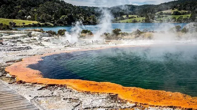
What Tarawera left behind is, in its own way, the reason so much of the geothermal activity around Rotorua looks the way it does now. The eruption is directly connected to why this whole area is geothermal in the first place — it’s part of the same Taupō Volcanic Zone system that produces Waimangu Volcanic Valley just south of the mountain, itself the only geothermal system on Earth with a known birth date, because it was created by this exact eruption. Frying Pan Lake and Inferno Crater didn’t exist before that night.
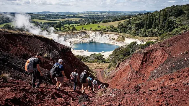
Today you can walk parts of the mountain, but only with a guide, and only because local iwi own it and control access — it isn’t a drop-in hike the way the Redwoods trails are. On a clear day the guided routes cross ash fields and craters that are still, in geological terms, freshly made. I’ve also flown over it, which gives you the version of the story the ground walk can’t: the full length of the rift, the row of craters, and how close the destruction sat to the lake and the Blue and Green Lakes just beyond it. If you’d rather see it from the air, an operator running a scenic flight over Tarawera and the Waimangu valley covers the same ground the eruption reshaped in about twenty minutes, which is an odd kind of time compression to sit with.
For a longer day that connects the mountain to the wider eruption zone, there’s a combined tour taking in Tarawera and Waimangu together, which is the version I’d recommend if you only have one day to give this. And if you want the gentler, closer-to-town geothermal picture that Tarawera’s activity ultimately feeds — the boiling mud and steaming ground rather than the mountain itself — an eco thermal afternoon tour around Rotorua covers that side of the story.
None of this reads as museum history when you’re standing at the lake edge. Lake Rotorua sits calm and ordinary a short drive north, and it’s genuinely disorienting to know that the ground under both lakes belongs to the same restless system. For context on how the region’s Māori history sits alongside this event, Te Arawa’s history in Rotorua is the better starting point than anything I can compress into this piece, and if geothermal risk in general is on your mind before a trip, how safe geothermal tourism actually is is worth reading before you plan around the parks.
Frequently asked questions about the Tarawera eruption
What caused the Tarawera eruption?
Mount Tarawera erupted after magma forced its way up along a roughly 17 km rift beneath the mountain and lake, part of the wider Taupō Volcanic Zone that runs through this stretch of the North Island. The eruption began just after midnight on 10 June 1886 and lasted about four hours.
How many people died in the Tarawera eruption?
An estimated 120 people died, mostly in villages near the mountain and lake, including Te Wairoa. It remains one of New Zealand’s deadliest natural disasters.
What happened to the Pink and White Terraces?
The famous silica terraces, then one of the country’s biggest tourist draws, were destroyed in the eruption. Exactly how — buried, blown apart, or a mix of both — is still debated among researchers, and no confirmed remnant has ever been reopened to visitors.
Can I visit Mount Tarawera today?
Yes, but only on a guided walk or scenic flight. The mountain is owned by local iwi, and access is controlled rather than open to independent hikers.
Is Mount Tarawera still active?
Geologically, yes — it sits within an active volcanic zone and is monitored accordingly, though it hasn’t erupted since 1886. It isn’t considered an imminent risk for a standard visit.
What is Te Wairoa, the buried village?
Te Wairoa was the staging village tourists passed through on the way to see the Pink and White Terraces before the eruption. It was buried in ash and mud that night, later excavated, and can now be visited as a historic site.
Could an eruption like 1886 happen again?
It’s not something anyone can rule out on a geological timescale, but there’s no indication of comparable activity building today. Rotorua’s civil defence and monitoring systems exist specifically because this history is well understood, not despite it.
Volcano & crater tours on GetYourGuide
Verified deep-linked GetYourGuide tours. Book through these links and we earn a small commission at no cost to you.
Photos show the destination, not the operator's own images.