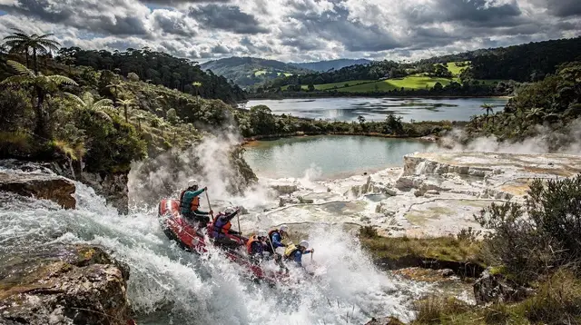
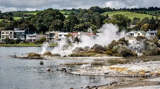
A lake reshaped by eruption
Lake Tarawera fills a basin at the eastern edge of Rotorua’s volcanic country, wrapped by native forest and dominated by Mount Tarawera rising along its southern shore. It is one of the largest lakes in the region, and unlike Lake Rotorua in the city centre, it has almost no lakeside development: no promenade, no marina strip, mostly bush running straight down to the water.
The lake’s modern shape and reputation both trace back to a single night. On 10 June 1886, Mount Tarawera split open along its summit and erupted for several hours, throwing ash and rock across the district and killing more than a hundred people. The eruption also destroyed the Pink and White Terraces, silica formations on neighbouring Lake Rotomahana that had drawn travellers to the region since the 1870s — read the fuller story in the 1886 Tarawera eruption and the loss of the Pink and White Terraces. The village of Te Wairoa, on Lake Tarawera’s western edge, was buried under ash and never rebuilt; its excavated remains are now Te Wairoa, the Buried Village, and the walking access to the lake’s eastern shore still starts from near this site.
Because of that history, a visit to Lake Tarawera tends to combine three things: a look at the volcano itself, some time on or beside the water, and — for anyone willing to walk a full day — a hot spring on the far shore that most visitors to Rotorua never see.
Te Rata Bay and the Hot Water Beach
The lake’s best-known feature is Te Rata Bay, on the eastern shore near the base of Mount Tarawera. Geothermal heat below the lakebed seeps up through the sand and rock at the water’s edge, warming a section of shoreline while the open lake beyond stays cool. The effect is similar in principle to the geothermal beaches on the Coromandel coast, but here it sits on fresh lake water rather than the sea, with the warm and cool zones shifting slightly depending on where the heat is coming through on a given day.
There is no road to Te Rata Bay. It is reached three ways: by boat, by kayak, or on foot along the Tarawera Trail. That isolation is part of what keeps it quiet compared with the geothermal parks closer to town — there is no car park, no kiosk, and no set schedule, so anyone visiting brings their own food, water and sun protection and times their trip around a boat, a paddle, or a full day’s walk. It sits within the same volcanic system covered in Rotorua’s other free hot springs, and the wider question of which geothermal pool suits which visitor is covered in the Rotorua hot pools guide.
Water temperature at Te Rata Bay is not controlled or monitored the way a commercial spa pool is. It varies with the geothermal activity underneath and with how much of the cooler lake is mixing in nearby, so conditions on any given day are not guaranteed to be warm, or safe for standing directly over a vent. Anyone visiting should treat it as a natural feature rather than a facility, and be ready to move along the shore to find a comfortable spot rather than expecting a fixed “hot pool.”
Walking the Tarawera Trail
The Tarawera Trail is a Department of Conservation track that runs along the lake’s eastern shore, starting near Te Wairoa and following the water past several bays before reaching Te Rata Bay. For walkers who want to keep going, the track continues further around the lake toward Humphries Bay and Stony Point, where a wider network of tracks and campsites links this area to other parts of the Bay of Plenty back country.
Reaching Te Rata Bay on foot from Te Wairoa is a full-day undertaking, not a short stroll — allow the whole day, carry water and food, and check current conditions before setting out, since sections can close after storms or slips. Many walkers arrange a one-way trip: walk in from Te Wairoa and arrange a water taxi or boat pickup from Te Rata Bay rather than retracing the same track, which cuts the day roughly in half. Others walk it as an out-and-back for a longer, more demanding day. Either way, this is a track for people who already do some walking, not a casual half-hour add-on to a geothermal park visit — for shorter, easier options around Rotorua, see Rotorua’s free walking tracks.
Because the track sits on land connected to Mount Tarawera and the Māori communities who hold it, some sections and the mountain’s summit itself are only open with a guide from the iwi. If the volcano rather than the lakeshore is the focus of a trip, guided walks on Mount Tarawera cover that access separately from the lake-level trail.
Given the distance and the lack of any shortcut back to a road, this walk suits capable, well-prepared hikers rather than families with young children or anyone short on time in Rotorua — it works best as the single planned activity for the day, not one stop among several.
Getting to the lake: road, boat and kayak
Reaching the lake edge near Te Wairoa or one of the boat landings is a short drive from central Rotorua. Getting further out onto the water — to Te Rata Bay, to the base of Mount Tarawera, or simply out onto open water for the view — needs a boat, kayak, or a booked cruise.
| Access point | How to get there | Good for |
|---|---|---|
| Te Wairoa / Buried Village area | Short drive from Rotorua | Starting the Tarawera Trail; visiting the buried village |
| Tarawera boat landings | Short drive, then launch by boat or kayak | Fishing, sightseeing, reaching Te Rata Bay by water |
| Te Rata Bay (Hot Water Beach) | Boat, kayak, or full-day walk only — no road | The geothermal hot springs on the lakeshore |
| Open lake and volcano views | Guided cruise or self-drive boat | Photography, views of Mount Tarawera from the water |
Kayaks can be launched from the public landings for anyone comfortable paddling a reasonably large lake, and this is one of several lakes covered in the broader guide to kayaking on Rotorua’s lakes. For a lower-effort option, guided lake cruises depart to take in the volcano and, on some routes, the connected waters around Lake Rotomahana — the Waimangu Volcanic Valley walk and Lake Rotomahana cruise combines a walk through that adjacent thermal valley with time on the water in the same eruption zone.
a combined walk through the Waimangu thermal valley and a cruise on Lake Rotomahana, next door to TaraweraFor a broader look at boat trips and paddling across the region’s lakes rather than this one specifically, see lake cruises and kayaking around Rotorua.
On the water: cruising, paddling and fishing
Lake Tarawera is also a working trout lake. Rainbow and brown trout are both present, and fishing here follows the same licensing rules as the rest of the region — and the same national rule that surprises many first-time visitors: trout cannot be bought or sold anywhere in New Zealand, so the only way to eat one is to catch it. Details on licences, guides and where to fish are in the Rotorua and Taupō trout fishing guide.
For visitors who want the geothermal side of the area without committing to the full Tarawera Trail, a shorter thermal-focused outing covers similar ground in less time.
a half-day thermal tour through Rotorua’s geothermal landscape for anyone short on timeAnd for a lake-based hot-water experience that doesn’t require a boat, kayak or full-day walk at all, a lakefront spa built around geothermal water is the easiest substitute for Te Rata Bay’s natural pools.
a lakefront geothermal spa experience with Māori wellness elements, as an easier alternative to the wild hot springsComparing the ways to experience Lake Tarawera
| Approach | Effort | Roughly | Reaches Te Rata Bay? |
|---|---|---|---|
| Tarawera Trail, one way with boat pickup | High — full day of walking | Free (walk) + water taxi fare | Yes |
| Tarawera Trail, out and back | Very high — long full day | Free | Yes |
| Kayak from a lake landing | Moderate — depends on paddling fitness | Kayak hire cost | Possible, weather and distance dependent |
| Guided lake cruise | Low | Tour price | Views of the lake and volcano; not always the bay itself |
| Lakefront geothermal spa (built facility) | Low | Entry price | No — separate substitute experience |
Best time to visit
Warm-water bathing at Te Rata Bay and general lake swimming are most comfortable from December to March, in line with the region’s summer, when air and lake temperatures are both at their highest — see Rotorua in summer for what that season looks like more broadly. The Tarawera Trail and lake cruises run through the rest of the year too; a winter walk is cooler and the days are shorter, but the geothermal steam rising off the warmer parts of the shoreline is often more visible against cold air, the same effect that makes Rotorua’s geothermal parks more atmospheric in winter.
Rain falls year-round in this region, and a wet day does not rule out a visit — a cruise or a paddle in light rain is often fine, though the full Tarawera Trail is a poor choice to attempt in heavy rain or after storms, since the track can be affected by slips. For nearby lakes with an easier, shorter comparison point, Tikitapu and Rotokākahi — the Blue and Green Lakes sit just over the ridge and make a good half-day pairing with a Tarawera lake cruise.
Where Lake Tarawera fits in a Rotorua trip
Because reaching the lake’s main draw takes either a boat or most of a day on foot, Lake Tarawera suits a trip with at least a few days in the region rather than a single rushed day in Rotorua. It slots naturally into a longer stay built around the area’s adventure and outdoor side — see the three-day adventure itinerary — or as one option among several when planning day trips from Rotorua more broadly.
Visitors basing themselves in Rotorua purely for geothermal parks and cultural experiences can safely treat Lake Tarawera as optional; those who enjoy walking, paddling or simply want to see the volcano responsible for the region’s most dramatic single event should build a half-day or full day around it.
FAQ about Lake Tarawera and Te Rata Bay
Is Lake Tarawera safe to swim in?
The open lake is generally fine for swimming in summer, in the same way as the region’s other lakes. Te Rata Bay’s warm zones are natural and unmonitored, so temperatures vary by location and by day — move to a different spot along the shore rather than assuming any one patch is safe to sit on directly.
How do you get to Te Rata Bay Hot Water Beach?
There is no road. Te Rata Bay is reached by boat, by kayak, or by walking the Tarawera Trail from Te Wairoa, which is a full-day effort on foot. Many walkers arrange a water taxi pickup from the bay rather than walking back the same way.
How long is the Tarawera Trail?
Walking from Te Wairoa to Te Rata Bay and back is a full day; continuing further around the lake toward Humphries Bay and Stony Point extends it considerably. Check current track conditions with the Department of Conservation before setting out, since sections can close after weather events.
Can you drive around Lake Tarawera?
No. Roads reach Te Wairoa and a handful of boat landings on the lake’s edge, but there is no road circling the lake and no vehicle access to Te Rata Bay.
Is fishing allowed on Lake Tarawera?
Yes, with a valid fishing licence, and the lake holds both rainbow and brown trout. As everywhere in New Zealand, trout cannot be bought or sold — catching your own is the only way to eat one.
What is the connection between Lake Tarawera and the 1886 eruption?
Mount Tarawera erupted on 10 June 1886 along the lake’s southern edge, killing more than a hundred people, burying the village of Te Wairoa, and destroying the Pink and White Terraces on neighbouring Lake Rotomahana. The eruption reshaped the surrounding landscape into roughly what visitors see today.
Do you need a guide to visit Mount Tarawera itself?
Access to parts of the mountain, including the summit, runs through the iwi who hold the land, and is guided rather than open for independent hiking. This is separate from the lake-level Tarawera Trail, which does not require a guide.
Is Lake Tarawera busy with tourists?
No — compared with Rotorua’s geothermal parks and cultural centres, Lake Tarawera sees relatively few visitors, largely because its main feature requires either a boat or a full day’s walk to reach.