Why Rotorua Is Geothermal
I noticed it on my first morning, before I’d had coffee. I was walking along a footpath near the lake and there was steam coming out of a crack between two paving stones, thin and steady, like the ground itself was breathing. A council worker walked past without even glancing at it. That’s when it clicked that this wasn’t a novelty laid on for visitors. It’s just what the ground does here.
A 250km tear, not a random hot spot
The reason Rotorua steams is not really about Rotorua at all. It’s about where Rotorua happens to sit. The city is built inside the Taupō Volcanic Zone, a stretch of the earth’s crust roughly 250km long that runs from the offshore volcano Whakaari / White Island in the north down to Mount Ruapehu in the south. Within that corridor, the crust is being pulled apart and is thinner than the rock around it, so magma sits closer to the surface than almost anywhere else on land. That magma heats groundwater, the groundwater looks for a way out, and what comes up is what you see and smell all over town: steam vents, boiling springs, mud pools and geysers.
Outside that 250km strip, New Zealand behaves like most other places. Auckland, three hours north, has old extinct volcanic cones but no steaming ground. Wellington has earthquakes from the same tectonic plate boundary but no geysers. It’s the combination of a rifting crust and shallow magma, in this one corridor, that makes the difference. I hadn’t quite grasped, before I got here, how narrow and specific that band is. It isn’t “New Zealand is geothermal.” It’s “this 250km strip of New Zealand is geothermal, and Rotorua happens to be built right in the middle of it.”
What that looks like on the ground
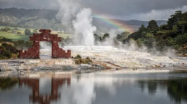
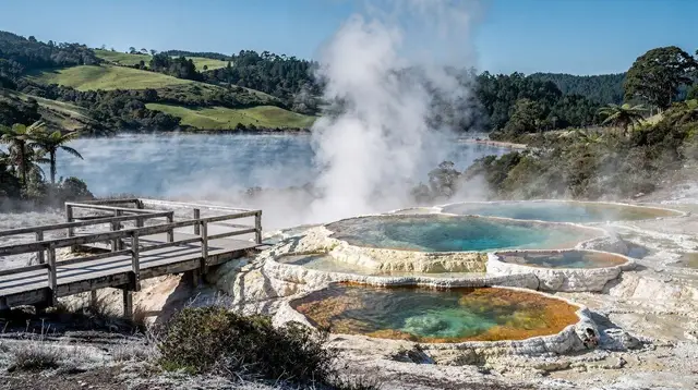
You can trace the zone by walking around town for a day. At Whakarewarewa, the geyser Pōhutu throws water up to thirty metres into the air, usually once or twice an hour, and it sits inside a valley shared with a living Tūhourangi Ngāti Wāhiao village where people still cook with the steam. A short drive south on the SH5, Wai-O-Tapu shows the same heat doing different chemistry: the Champagne Pool’s orange rim comes from minerals precipitating out of the water, and the Lady Knox geyser erupts on cue each morning once a surfactant is added to break the water’s surface tension. Northeast on the SH30, Hell’s Gate is the most visibly active of the lot, with a mud bath you can actually get into.
Then there’s Waimangu, which is different again because its birth is on record: the whole valley was created in a single eruption on 10 June 1886, from Mount Tarawera, which split open and buried the village of Te Wairoa along with the Pink and White Terraces. Waimangu is, as far as anyone knows, the only geothermal system on the planet whose starting date is that precisely documented. Standing at Frying Pan Lake, which is one of the largest hot springs in the world, it’s strange to think the whole basin didn’t exist before 1886. The zone doesn’t just produce steady features like Pōhutu — it occasionally produces sudden, violent new ones.
Living on top of it
What surprised me more than the geysers was how ordinary it all feels to people who live here. Kuirau Park is a free public park in the middle of town with boiling craters and steaming lawns, and locals walk dogs past it like it’s any other green space. Te Arawa people have lived with this geothermal ground for centuries, using it to cook, to heat homes, and to bathe, and the culture around it is lived rather than staged — I’d recommend reading up on Māori cultural etiquette in Rotorua before visiting a marae or a cultural performance, because this isn’t a theme park built over the geology, it’s a place people call home that happens to sit on it.
That said, the ground demands respect the marked areas don’t get automatically from being pretty. Thin crust and near-boiling water are real hazards, which is why the parks route you along boardwalks rather than letting you wander. If you want the specifics before you go, the guide on staying safe around Rotorua’s geothermal ground is worth five minutes, and it’s also why I’d rather book a guided trip through somewhere like the off-the-beaten-track geothermal walk with a local guide for areas that aren’t part of the standard boardwalked parks — someone who reads the ground for a living notices things I wouldn’t.
Where the zone ends
The Taupō Volcanic Zone doesn’t stop at Rotorua’s city limits. Drive an hour south and you’re in Taupō, sitting on the rim of a crater left by a past super-eruption, with Lake Taupō filling the basin. Keep going and you reach Tongariro National Park, where Ngauruhoe and Ruapehu mark roughly the southern end of the same active corridor. In the other direction, north past Whakatāne, the zone runs offshore to Whakaari/White Island, still actively venting. Rotorua isn’t an isolated curiosity — it’s the inland, walkable middle section of a much longer active system, which is part of why day trips to Taupō or Waimangu feel geologically continuous rather than like leaving for somewhere unrelated.
What I’d tell a first-timer
Don’t expect the geothermal activity to announce itself with drama everywhere you go — most of the city is ordinary streets and a lake. The steam and the smell are concentrated in specific, well-marked places, and that concentration is itself the clue: it tells you exactly where the crust is thinnest. If you want an easy first look before deciding which parks are worth a full visit, an afternoon on the eco thermal afternoon tour covers several sites without committing a whole day, and if you only have time for one park, I’d still put a Wai-O-Tapu entry ticket near the top of the list simply because it shows the widest range of what this rift in the crust actually produces in one walk.
For picking between parks properly, the comparison guide on Rotorua’s geothermal parks goes into more detail than I can here.
Frequently Asked Questions About the Taupō Volcanic Zone
Why is Rotorua geothermal?
Rotorua sits inside the Taupō Volcanic Zone, a roughly 250km tear in the earth’s crust running from Whakaari/White Island to Mount Ruapehu, where the crust is thin enough for magma to heat groundwater close to the surface. That heat escapes as steam, geysers, mud pools and hot springs across the Rotorua and Taupō districts.
What is the Taupō Volcanic Zone exactly?
It is a stretch of continuously active volcanic and geothermal country running roughly 250km through the central North Island, from the offshore volcano Whakaari/White Island in the north to Mount Ruapehu in the south. Rotorua and Taupō both sit inside it, which is why both towns are geothermal while most of the rest of the country is not.
Why does Rotorua smell of sulphur but other New Zealand cities don’t?
The smell is hydrogen sulphide gas escaping with the steam from geothermal ground beneath the city. Rotorua sits directly on that active ground; most other New Zealand towns simply do not. There’s more detail on this in the guide to why Rotorua smells of sulphur.
Is the ground in Rotorua actually dangerous?
Marked geothermal areas carry real risks, including thin crust and scalding water, which is why boardwalks, fences and guided routes exist and should be respected. Away from those active sites, day-to-day life in Rotorua is not more dangerous than any other New Zealand town.
Does the volcanic zone extend all the way to Taupō?
Yes. Taupō, about an hour south of Rotorua, sits at the other end of the same zone, on the crater left by a past super-eruption, and the Tongariro volcanoes further south mark its southern edge.
Will Rotorua’s geothermal activity ever stop?
No one can say on what timescale, but the zone has been active for a very long time and shows no sign of switching off. Geysers and hot springs do shift in activity over years and decades as underground plumbing changes, which is part of why checking current conditions with the park operator before a visit is worthwhile.
Geothermal park tours on GetYourGuide
Verified deep-linked GetYourGuide tours. Book through these links and we earn a small commission at no cost to you.
Photos show the destination, not the operator's own images.